Bemutatjuk a Magyar Nemzeti és Történelmi
A Magyar Nemzeti és Történelmi Jelképek oldalt a Nemzeti Infokommunikációs Szolgáltató Zrt. készítette és működteti.

Magyarország alaptörvénye
Az alkotmány a jogforrási rangsor csúcsán álló alaptörvény, amely a társadalom működésével kapcsolatos érdekeket és célokat, az állam belső szabályozására és külkapcsolatára vonatkozó alapelveket mondja ki. Magyarország Alaptörvénye az állam legmagasabb szintű törvénye, egyetlen jogszabály sem lehet ellentétes vele. Ezen alapelv betartása felett az Alkotmánybíróság őrködik.
A parlament 2011. április 18-án fogadta el az új alaptörvényt, amely 2012. január 1-jén lépett hatályba.
Megtekintés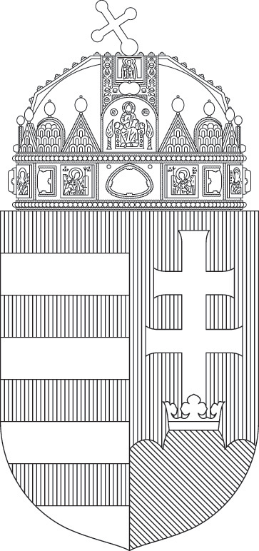
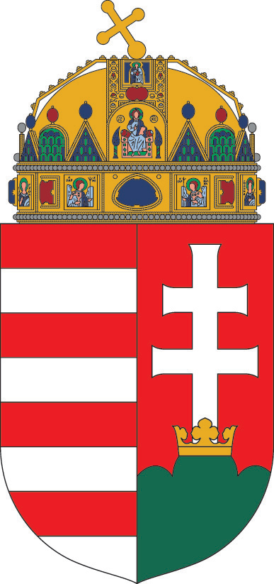
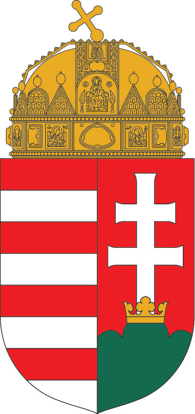
A Magyar Köztársaság címere
A Magyar Köztársaság címere megfelelő – a heraldika hagyományait is tiszteletben tartó – ábrázolásának szabályait és annak lehetséges változatait az MSZ 3500:2012 hivatkozási számú szabvány rögzíti.
E szabvány alapján készítettük el a címer vektorgrafikus ábrázolását, mely a kormányzati és a nonprofit szektor számára szabadon letölthető és felhasználható oldalainkról. A letöltött anyagok üzleti célú felhasználása nem engedett. Kérjük, használat előtt olvassa el a Magyar Köztársaság címere használatának jogi hátteréről, fő elveiről és kritériumairól SZÓLÓ FEJEZETET.
Zászlók
A nemzeti zászló történelme
Nemzeti zászlónk hosszú fejlődés során alakult ki. A magyarok - a krónikák tanúbizonysága szerint - fekete turulmadárral díszített vörös zászlók alatt harcoltak. E hadijelvényeket később felváltották a szentek képeivel kivarrott zászlók. (Például Szent István „Szent György és Szent Márton zászlaja alatt" vonult csatába.) Később a vörös-ezüst sávos zászló (esetleg kiegészítve az uralkodó dinasztikus színeivel) vált általánossá.
Bár a XV. századtól egyre gyakoribb a vörös-ezüst-zöld sodrás az oklevelek pecsétjeinek selyemzsinórzatán, illetve olykor a hadizászlók peremfogazatán is megjelenik, valójában csak 1806-ban írják le a ma is használatos sorrendben, s csak az 1848. évi XXI. törvénycikk írja elő hivatalosan először a „piros-fehér-zöld" színek használatát.

Történelmi zászlók galériája
Galériánkban bemutatjuk nemzetünk történelmi zászlóit egészen a honfoglalástól napjainkig.
Galéria megtekintése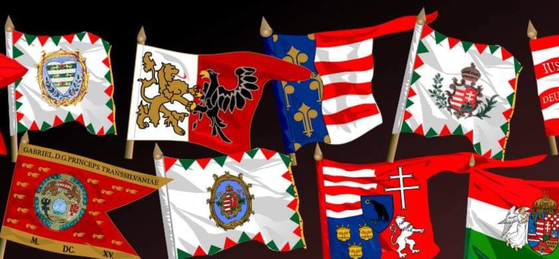
Ékszerek
Az alábbi felsorolásban bővebben olvashat a Szent Koronáról és a koronázási ékszerekről.
Ugyanakkor 1166 körül egy bizánci szónok Mánuel császárt dicsőítő beszédében már úgy fogalmaz, hogy a magyar békekövetség többek között felajánlotta néki: „A te jogarod alatt vétessen jegyzékbe Paionia koronás temploma a körülötte lévő székvárossal, hogy a paion uralkodók királyi koronája a te hatalmasságodnak legyen függvénye." Egyértelmű tehát: a 12. század közepére már kialakultnak tekinthető az a szokás, hogy a koronázási jelvényeket Székesfehérvárott őrzik, és a magyar királyok hatalma egy bizonyos koronával - a Szent Koronával - való koronázás függvénye. E két időhatár között kell tehát nyomoznunk, amikor a korona eredetét keressük.
A 11. század második felében a világi hatalomra törő pápaság és korábbi oltalmazója, a Német-római Császárság között súlyos viszály támadt. Mindenekelőtt azért mentek ölre, hogy kinek a joga legyen az invesztitúra, azaz a legtöbbször hatalmas földbirtokkal járó egyházi méltóságok betöltése, a főpapok kinevezése. A németekkel hadilábon álló László király ebben a küzdelemben eleinte a pápát támogatta. Uralma vége felé azonban megszállta Horvátországot, amelyre hűbéri jogon a Szentszék is igényt tartott, ezért viszonyuk ellenségessé vált. László utódja, Kálmán, aki e foglalásokat nemcsak megtartotta, de gyarapította is, úgy próbálta elismertetni hódításait és megengesztelni az egyház fejét, hogy 1106 októberében a guastallai egyetemes zsinaton lemondott az egyházfő javára a magyarországi főpapok kinevezési jogáról.
Ám nem véletlenül írta egy kortárs lengyel krónikás, hogy Kálmán a „tudományával felülmúlta korának összes uralkodóját”. Hamarosan kigondolta, hogyan járjon túl a pápa eszén, hogyan szerezze vissza elveszett jogait. Alig egy esztendővel korábban adta feleségül unokahúgát, Szent László leányát a bizánci császárhoz. Piroska kiházasításával kapcsolatos tárgyalásain tapasztalhatta, hogy a császár dölyfösen semmibe veszi a pápai törekvéseket. Arra hivatkozik, hogy legfelségesebb elődje, a kereszténységnek hajdan szabad működést engedélyező Nagy Konsztantinosz császár az Isten kiválasztottja volt, ezért a mindenkori bizánci uralkodó is teosztefész, vagyis Isten által koronázott császár. Megvolt tehát a minta: jogilag hasonlóvá kell változtatni a magyar királyságot is. De hogyan? Ehhez egy olyan isteni eredetű korona kellett, amely a korabeli emberek vallásos misztikuméhségét kielégíti, és kellőképp alátámasztja a magyar uralkodó országa egyházainak igazgatására irányuló törekvéseit.
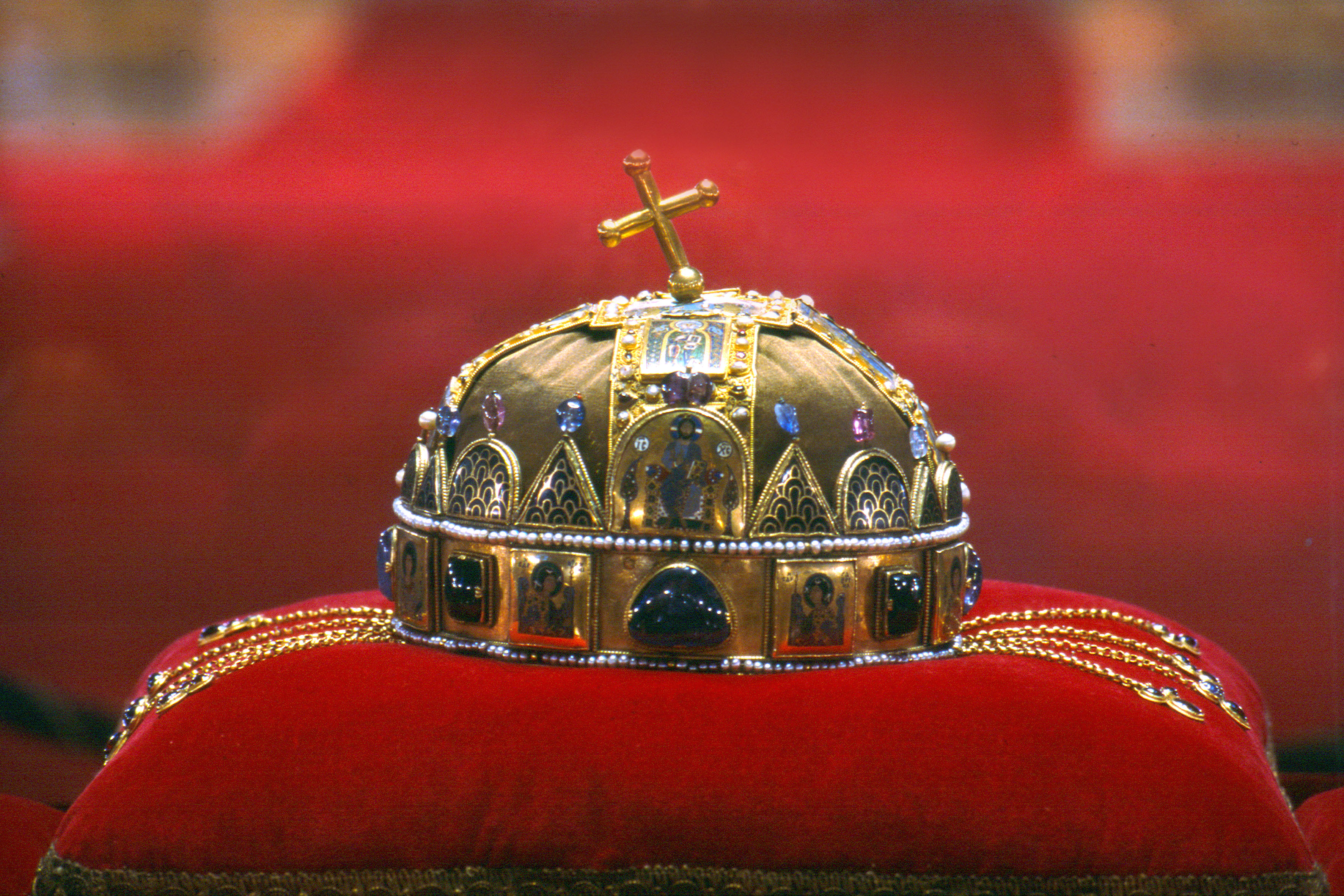
Kálmán kincstárában volt egy csodálatosan szép arany abroncskorona, amelynek peremeit igazgyöngysor ékesítette, lemezét pedig hatalmas drágakövek — zafírok és almandin-gránátok — díszítették. Az ékkövek között szimmetrikusan az égi pártfogók (Gábriel és Mihály arkangyal), az evilági élet biztonsága fölött őrködő katonaszentek (Szent György és Demeter), majd az egészséget biztosító orvosszentek (Szent Kozma és Damján) szépen megmunkált zománcképei helyezkedtek el. Elöl, az abroncs fölött félkör alakú és háromszögletű, színes, hegyükben drágakövet tartó, azsúr rekeszzománc oromdíszektől közrefogva az égi trónuson ülő, világszabadító Krisztus finommívű képe díszelgett. A korona hátsó részén, mintegy Krisztus mennyei hatalmának földi tükörképeként igazgyöngysorral övezve Dukász Mihály bizánci császár ikonszerű mellképe volt látható, tőle jobbra az abroncson társcsászárának, Konsztantinosznak, balra pedig I. Géza magyar királynak a portréját foglalták zománcba. A diadém két oldalán négy-négy, hátul pedig egy aranylánc csüngött le, végeiken három-három drágakővel.
Ez a női korona (szaknyelven sztemma) közel állt Kálmán szívéhez, hiszen nevelőanyja, Szünadéné viselte, akit ezzel talán Gézával kötött frigye alkalmából ajándékoztak meg. Igen ám, de ennek a koronának semmi köze nem volt a magyarság keresztény hitre térítésében oroszlánrészt vállaló, első magyar királyhoz, az időközben szentté avatott Istvánhoz, így isteni eredetét azonnal kétségbe lehetett vonni. Kálmán pedig - akinek a pápa is ezt írta: „szokatlan járatossággal tűnsz ki az egyházi írások tudományában s az egyházjog ismeretében” - nagyon jól tudta, hogy Szent Istvánnak II. Szilveszter pápától elnyert koronáját III. Henrik német-római császár - amikor Aba Sámuel ellenkirályt 1044-ben legyőzte, és kincstárát elragadta - visszaküldte Rómába, s helyette ő adott a trónjára visszahelyezett Péter királynak a német hűbért fémjelző hatalmi jelvényeket. De azt is jól tudta, hogy keresztény felfogás szerint minden megszentelődik, ami valamilyen módon kapcsolatba kerül a szentek ereklyéivel. Gondolt tehát egy merészet, s előhozatta Szent István koponyájának ereklyetartóját. Ezt a két-két arany keresztpántból félgömböt formázó reliquiáriumot Szünadéné koronájának képeit jól ismerő (de az is lehet, hogy alkotó) hazai ötvösművészek készítették. A főhelyet a pántok találkozásánál itt is a világmegváltó Krisztus zománcképe uralta egy közepébe épített kereszttel. A pántokra pedig oldalanként három-három (más elképzelés szerint eredendően is két-két) tanítványának ugyancsak rekeszzománcból készített képét helyezték el. Így juttatták kifejezésre, hogy István hasonlatos hozzájuk, ő a magyar nép igazi apostola.
Kálmán úgy döntött, hogy ezt, a szent király csontjai által megszentelt ereklyetartót összedolgoztatja anyja koronájával, s így egy olyan zárt koronára (akkori nevén kamelaukionra) tesz szert, amilyent ez idő tájt kezdtek a császárok viselni. Mivel a koronát Szent István egykor II. Szilvesztertől kapta, aki jelentős természettudós, matematikus, csillagász és kronográfus volt, a kiválóan képzett király a korona összeillesztésénél figyelembe vétette a korának minden kozmológiai és kabalisztikai ismeretét, ugyanúgy, ahogy a szent király akkor ismert eszméit is, hogy növelje az új jelvény Szent István-i eredetének hitelét, és az kielégítsen minden teológiai és tudományos igényt. (Más feltevés szerint az abroncs is eredendően része volt az ereklyetartónak, csak a világi uralkodók hármasának rekeszzománc képei nélkül. Ha ez így igaz, az említett képek csak I. Géza és Kálmán idejében lehettek kiemelt szerepűek. Ám Géza már jóval a szentté avatás előtt meghalt, tehát ismét csak Kálmán lehetett az, aki ezeket a koronára helyeztette.)
A korona tehát elkészült, de hiányzott hozzá az a magyarázat, amely megkérdőjelezhetetlenné teszi, hogy viselőjének joga van országa egyházi ügyeinek intézésére. Kálmán e problémára is megtalálta a megfelelő megoldást. A tudós győri püspökkel, Hartvikkal újra megíratta István életrajzát, és ezt a legendaváltozatot kanonizáltatta, hitelesíttette az egyházzal. Ám ebbe már belefoglaltatta a szent király koronakérésének históriáját az alábbi módon: a lengyelek fejedelme, Mjeskó elküldte követeit a pápához, hogy számára királyi felségjelvényeket kérjenek. A római főpap méltányolta is folyamodásukat, s elkészíttette a kért koronát. De mielőtt átnyújthatta volna azt a lengyel követségnek, éjjel, álmában látomása volt: megjelent neki Isten angyala, és közölte vele, hogy másnap egy ismeretlen nép követei jönnek ugyancsak koronát és apostoli áldást kérni, s az ő szentéletű uralkodójuknak kell az új diadémot elküldenie. A felserkent pápa kételkedett látomásában, és úgy döntött, igazolják vagy cáfolják annak hitelét az események. Reggel azonban megjelent előtte Asrik érsek, és előadta a magyarok királyának kérelmét. Mit tehetett erre a pápa? Bár a lengyeleknek szánta a koronát, isteni intésre mégis Istvánnak küldte el azt.
Ez a kis – látszólag ártatlan legendabeli – epizód csalafinta módon, nagyon is nyomós mondanivalót hordozott: azt, hogy a magyarok királya koronáját, a pápai szándék ellenére, magától az Úristentől nyerte el. Tehát a magyar uralkodó is - miként a bizánci - teosztefész, azaz Istentől koronázott király, ezért országa ügyeibe senkinek nem lehet beleszólása, ő maga pedig senkinek nem tartozik felelősséggel, csak egyedül az Úristennek. A magyarság, Magyarország sorsa nem függhet sem császároktól, sem pápáktól, hanem egyedül az Isten kezébe van letéve.
A korona pedig ettől kezdve mind szorosabb szálakkal kötődött Szent István emlékéhez, jogilag a királyi hatalom fölé emelkedett, a magyar király Istentől nyert uralmának, a magyarság független állami létének szimbólumává vált; s bár történelmünk folyamán sokszor idegen dinasztiák tagjai viselték, ezt a jelentését mindvégig megőrizte.
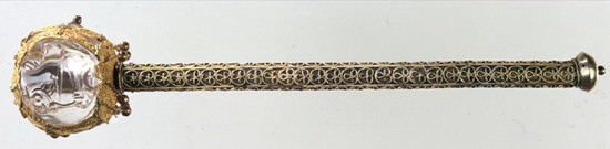
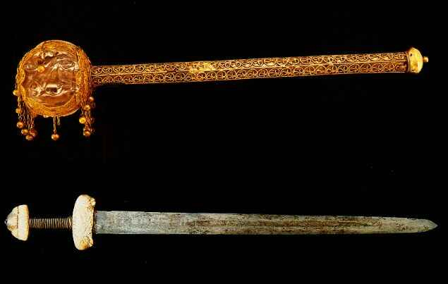
A szent korona mellett a magyar koronázási ékszerek talán legcsodálatosabb darabja a jogar, amelynek különlegessége, hogy buzogányra emlékeztető alakja eltér minden más jogarétól.
A feje egy víztisztaságú, áttetsző kvarckristályból csiszolt gömb. Ezen alul és felül egy-egy, tíz sziromlevélre tagolódó, virágkehely alakú aranylemez van, amelyeket hat ponton, majdnem szimmetrikusan, három kettőspánt fog össze. A lemezkék felületét arany huzalból kialakított, gombostűfej nagyságú gömböcskék sorának tetsző háló, filigrán díszíti, melynek uralkodó motívuma a felezett szívpalmetta. (Ezen a palmetta, azaz a pálmalevél mintát úgy felezik meg, hogy szív alakú képet adjon,) A felső lemez közepére préselt, gyöngyözött szalagokból végtelenített vonalmintát formázó, titokzatos, bűvös jelet forrasztottak, amelyről azt tartották, hogy - éppen végtelenségénél fogva - képes távol tartani a gonosz, ártó szellemeket. A hegyikristály gömbbe három oldalon egy-egy kuporgó oroszlánt metszettek. A kristálygömb a X. századi Egyiptomban készült, ahol Mohamed próféta - az iszlám vallás alapítója - leányának, Fatimának utódai uralkodtak. Itt az oroszlán, mint jelkép, a fejedelmi méltóság legtökéletesebb teljességének hordozója volt, de átkerülve Európába megőrizte az erős királyi hatalmat szimbolizáló jelentését. A gömb foglalatára aranyláncocskákon függő kis aranygolyócskákat erősítettek, amelyek a jogar minden mozdításakor összeütődve csilingelésükkel - mint hitték - ugyancsak elriasztják a rossz szellemeket.
Az átfúrt kristálygömbbe mogyorófa nyél illeszkedik. Ehhez a növényhez is fűződtek babonás hiedelmek; elegendő itt csupán arra utalni, hogy Szent László hercegnek a mogyoródi csata előtt éppen egy mogyoróbokorból ugrott lándzsájára a győzelmét megjövendölő hófehér hermelin. A nyelet aranyozott ezüstszálból készített, a fej fémrészeinek filigrándíszítését utánzó, egyszerűbb mintázat borítja. (A különböző anyag és a némileg eltérő minta bizonyítja, hogy e tárgy hosszú ideig volt használatban, és közben többször szorult javításra.)
Pontosan nem tudjuk, mikor került a jogar koronázási jelvényeink közé. A kristálygömb kora azt sugallná, hogy Szent István kincsei között lehetett a helye. Ám az ő egyetlen hitelesnek tekinthető képén - hasonlóan az egykorú II. Baszileosz bizánczi és II. Henrik német-római császárokhoz - baljában országalma, jobbjában lándzsa van. A bizánci császárt ábrázoló kis képen (miniaturán) a lándzsát Mihály arkangyal, a halál hírnöke adja az uralkodó kezébe: a lándzsa tehát az élet-halál feletti uralmat jelképezi.
István király lándzsáját azonban a trónbitorló Aba Sámuelt legyőzve III. Henrik császár a koronával együtt visszaküldte Rómába, és helyettük ő adott a trónjára visszahelyezett Péter királynak hatalmi jelvényeket, amelyek között ott lehetett a császári Szent Móric lándzsa egyszerűbb másolata is. Ám ezt a hűbéri függést kifejező díszfegyvert a Pétert elűző I. András aligha vette át, helyette a magyar múltban keresett olyan jelvényt, amely az uralkodó háború és béke, élet és halál feletti jogát kifejezi. És találhatott is ilyent.
A krónikákban feljegyezték Botond históriáját, aki - hogy a magyarok hadüzenetét nyilvánvalóvá tegye - Bizánc érckapuján egyetlen csapással akkora lyukat szakított, amelyen egy ötéves gyermek ki-be futkoshatott. Majd fegyvertelenül birokra kelt egy görög óriással, és rövid idő alatt úgy beleverte a földbe, hogy elszállt belőle a lélek. A krónikások ugyan itt harci baltát (dolabrum) említenek Botond fegyvereként, de szerencsére azt is elmondják, hogy ezt a történetet „a parasztok hamis meséiből" emelték át művükbe. A mesében azonban nem balta szerepel. Amikor az elrabolt királylánnyal beszélget a mesehős „rettenetes nagyot mennydörög a kapu. - Az én uram, a hétfejű sárkány vágta a buzogányát a kapuba! - mondja a leány." Mégpedig éppen úgy, mint Botond, hadüzenetként, mivel tudja, hogy az ellenfél a házban tartózkodik. Ezt követi a fegyvertelen birkózás, földbe verés, elpusztítás. De ha ez így van, miért baltát írtak a krónikások? Bizonyosan azért, mert a meséket a nép nyelvén hallották, s ekkor még nem került át a magyar nyelvbe a török buzogány szó, hanem ezt a fegyvert egyszerűen botnak nevezték. Azt pedig a harci ismeretekben otthonosan mozgó történetírók teljességgel elképzelhetetlennek tarthatták, hogy holmi bottal be lehessen zúzni egy érckaput; írtak tehát baltát nem törődve azzal, hogy ez utóbbi rést hasít és nem lyukat szakít.
Azt, hogy a ma ismert koronázási jogart először I. András használta volna, nem állíthatjuk, de a buzogányforma ekkoriban alakulhatott ki. És, mert a magyar nyelvben a jogar szót csak a nyelvújítás korában alkották, korábban a jogart is pálcának, botnak nevezték. A korabeli orosz nyelvben is a палица egyaránt jelent botot és buzogányt, I. András felesége pedig kijevi hercegnő volt. Nem lehet véletlen tehát, hogy amikor 1055-ben a király megalapítja a tihanyi apátságot, az alapítólevélben önmagát a bizánci császárok példájára „a legkeresztényibb jogarviselőnek" nevezi. Mert ha a X. század közepén, Botond idejében, a buzogány volt a hadüzenet eszköze, amely a fejedelem döntési jogát fejezte ki a háború és béke ügyében, miért ne térhetett volna vissza András király ehhez a jelvényhez akkor, amikor a magyarság hűbéri alávetéstől mentes, független állami létét és ebből következően önálló külpolitikáját kívánta hangsúlyozni?
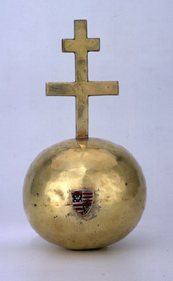
A középkorban a régi Róma dicsőségére áhítozó német-római császárok ismét felvették jelvényeik közé a kereszttel ékesített gömböt. De eredeti jelentését már egyáltalán nem ismerték, így elfogadták a keresztény teológusok tudálékos magyarázatait, akik szerint ez a királyi ékszer jelképezi először: a kezdet és vég nélküli, örök isteni irgalmasságot, amelyben felkenésekor az uralkodó is részesült. Másodszor: figyelmeztet arra, hogy a királyok sorsa, szerencséje nagyon is forgandó lehet, és éppen ezért - harmadszor - emlékezteti a fejedelmet, hogy ő is, akár a többi ember, halandó, porból vétetett, és porrá lesz, üdvösségét ő is csak (a gömbön is megjelenített) kereszttől remélheti. Ennek a magyarázatnak a nyomatékosítására két félgömbből állíttatták össze a glóbuszt, és közéjük Krisztus kínszenvedésének helyéről, a jeruzsálemi Golgota hegyéről hozott földet rakattak. A császárokat utánzó többi keresztény uralkodó azután már ezzel a jelentéstartalommal vette át ezt a jelvényt a sajátjai közé.
Így történt ez Magyarország esetében is. Koronázási palástunk tanúskodik felőle, melyen ábrázolták Szent Istvánt is, s baljában már ott a glóbusz. Pénzek veretképei, pecsétek lenyomatai, képi ábrázolások sorozata bizonyítja, hogy használata a magyar királyság egész időszakában folyamatos volt. Mégsem állíthatjuk azt, hogy e királyi jelvényünk esetében minden rendben van.
A ma ismert országalmánk egyszerű, dísztelen, kissé lapított, aranyozott ezüst gömb. Tetején lemezből készült kettős kereszt, amelynek magassága közel azonos a gömb átmérőjével, alsó szárának hossza ennek kétharmada, felső száráé pedig harmada lehet. A gömb közepén, a kereszt síkjával párhuzamosan, elöl és hátul egy-egy kicsiny, háromszögletű, zománcozott címerpajzs van.
Mit tudunk ezekről a pajzsokról leolvasni? Közismert, hogy a pajzs (eredeti rendeltetése szerint) a harcos védelmére szolgált. A címertan (heraldika) szakemberei tehát úgy szokták leírni a címereket, mintha mögötte állva maguk elé tartanák a pajzsot: a címertani nézet így éppen az ellenkezője a szembenézetnek. Pajzsunkat egy függőleges vonal, amit szaknyelven hasításnak, és egy, a címer felső élével párhuzamos vonal, amelyet vágásnak neveznek, négy mezőre osztja. A jobb felső és a bal alsó negyedben egy-egy arany liliom található azúrkék mezőben, amelyet vörössel rótt ezüstkeret övez. A bal felső és ugyanígy a jobb alsó negyedben az ezüst mezőt három vörös sáv osztja hat részre: három ezüst és három vörös pólyára. Ez a két kis pajzs tehát az Anjouk liliomos és az Árpádok vörös-ezüst sávos címereit egyesítve ábrázolja úgy, ahogyan az Károly Róbert 1301-ben vert dénárjain is látható. Úgy tűnik, országalmánk sem régebbi ezeknél a pénzeknél. Hogyan? A magyar királyoknak korábban nem volt országalmájuk? De, volt!
Már a Szent István idejében készült koronázási paláston úgy ábrázolták az uralkodót, hogy baljában gömböt tart. Ám ezen a glóbuszon csak egyszerű kereszt van. Pedig István királyról tudjuk, rendelkezett olyan ereklyetartóval, amelybe Krisztus keresztjének egy szilánkját rejtették. Az ilyen tokokat (eredeti görög néven sztaurotékákat) pedig kettős kereszt alakúra mintázták. Azt tartották ugyanis, hogy az eredeti fadarab Krisztussal érintkezve megszentelődött, tehát így magát az Üdvözítő megfeszített testét (amit a szobrászok korpusznak hívnak) szimbolizálja; ha pedig ezt keresztre helyezik, értelemszerűen kialakul a kettős kereszt forma. Krisztus keresztjét I. Hérakleiosz császár (610-641) óta Bizáncban őrizték, ezért majd minden keresztereklye, közvetve vagy közvetlenül, innen származott.
Kálmán királyunk (1095-1116), aki királyságát jogilag a pápától független, „Isten által koronázott" (teosztefész) bizánci császáréhoz kívánta hasonlatossá tenni, amikor megíratta Hartvik győri püspökkel István király legendáját, belefoglaltatta azt a gondolatot is, hogy a pápa „keresztet küldött a királynak, mintegy az apostolság jeleként, így szólván: Én apostoli vagyok, ő viszont méltán Krisztus apostola ..., ezért rábízzuk, hogy úgy irányítsa egyházait és népeit mindkét (egyházi és világi) törvény alapján, ahogyan az isteni kegyelem őt erre kioktatja." Annak tárgyi bizonyítékául pedig, hogy a pápa tényleg lemondott István javára a magyar egyházak igazgatásáról, felmutathatták az István-féle keresztereklyét, amit ettől kezdve hazánkban apostoli keresztnek neveztek.
És mivel minden sztaurotéka, mint említettük, végső soron Bizáncra utal, nem lehet véletlen, hogy akkor szerepeltették nyomatékkal a magyar királyok jelvényei között, amikor valamelyik uralkodónk Bizánc felé kacsintgatott. III. Béla (1173-1196), aki egy ideig a bizánci trón várományosa volt, pénzeire kettős keresztet veretett, fia, Imre király (1196-1204) pedig - talán Komnénosz Mánuel császártól lesve el az ötletet - az eredeti glóbusz helyett Szent István kristálygömbre helyezett keresztereklyéjét használta országalmaként, és ezt vésette nagypecsétjébe is.
Utódaik is használják pecsétjeiken ezt a kereszttípust, országalmán pedig akkor fordul ismét elő, amikor az az Anjou származású Károly Róbert kerül a magyar trónra, akinek a családja, amióta a dédnagypapája megvetette lábát Itáliában, mindig a Bizánci Birodalom megkaparintását tekintette legfőbb céljának. Csakhogy a Szent István keresztjével díszített országalmát (amely talán azonos lehet a salzburgi dóm kincstárában őrzött, azóta talpra helyezett, magyar királyi eskükereszttel) időközben Anna, macsói hercegnő, más koronázási ékszerekkel együtt, elragadta az országból (1271-ben). Ez lehet a magyarázat arra, hogy Károly Róbert kénytelen volt a korábbi mintát utánozva új országalmát készíttetni, de ennek egyszerű küllemével és címerének reáhelyezésével azt is jelezte - talán remélve az eredeti visszakerülését -, hogy ez nem az ősi jelvény.
Nagyon keveset tudunk arról, hogy koronázási szertartásunkban milyen szerepet játszott az országalma. A koronázási menetben V. László, Mátyás, II. Ulászló előtt világi főrangúak vitték. Bár I. Ulászló koronázásáról azt említik a források, hogy az esztergomi érsek nyújtotta át neki az országalmát, mégis úgy tűnik, hazánkban ez az uralkodói méltóságjel háttérbe szorul, az egyház nem tud mit kezdeni vele. Miért? Talán az elnevezése miatt. Már az első hiteles leírás is, amely III. András 1290-es koronázásáról korunkra maradt egy kortárs német költő tollából, „aranyalmának" (Aphel guldin) nevezi a glóbuszt, és ez az elnevezés a latinul író krónikások tanúbizonysága szerint (akiknél „pomum aureum" szerepel) is végig fennmaradt, hiszen mi ma is - eltérően más népektől, amelyek „globe royal" (francia), „globo imperiale" (olasz), „orb" (angol), „gyerzsava" (orosz) stb. nevekkel illetik - „országalmáról" beszélünk. Igen ám, csakhogy a középkori keresztény Európában az alma a bűn, a halál, a gonoszság jelképe volt, amellyel a kígyó képébe bújt sátán - a legenda szerint - ősszüleinket, Ádámot és Évát megrontotta. Az egyházban akkoriban használt latin nyelvben pedig a „malum" szó egyszerre jelentette az almát, de a bajt, bűnt, gonoszságot, szerencsétlenséget is, így érthető, ha az egyház idegenkedett ettől a jelvénytől.
Ám, ha az egyháznak nem volt szimpatikus ez az elnevezés, hogyan élhetett akkor ilyen szívósan mind a mai napig? Az ősi gyökerek kitéphetetlenségét igazolva. Pogány hiedelemvilágunkban, amelyet népmeséink híven őriztek meg, az (arany, ezüst, réz) alma a sárkányok által a túlsó világra elragadott gazdagság, bőség, termékenység jelképe, amelyet a szabadító hős, legyőzve a gonoszt, ismét felhoz evilágra, mindenki bőségére, boldogságára. És mivel az ősi időkben a legnagyobb hősök lettek a közösség vezetői, magától értetődőnek tűnt a nép szemében, hogy a király, mindenki ura és parancsolója, akitől az ország jóléte és boldogsága függ, birtokolja ezt az aranyalmát. Így mesélték ezt még akkor is, amikor már nyilánvaló volt, hogy sok uralkodó nem szolgált rá népe bizalmára.
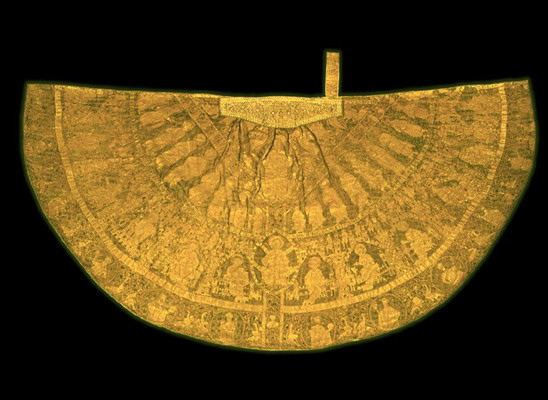
Hazánkban is ez volt a gyakorlat: történelmünk folyamán se szeri se száma az egyházak ilyen megadományozásának, hiszen már Szent István törvényben írta elő, hogy az épülő új templomok szertartáskönyveit a püspök adja, de ruhákról és oltárterítőkről a király gondoskodjék. Nemcsak rendelkezett, hanem cselekedett is. Amikor például 1030-ban seregeitől a hazánk leigázására törő II. Konrád német-római császár csapatai csúfos vereséget szenvedtek, fogadalmi ajándékképpen csodálatos kazulát (harang alakú miseruhát) készíttetett a székesfehérvári - Mária Istenanya tiszteletére szentelt - bazilika számára drága keleti brokátból, mintás selyemszövetből gazdag aranyhímzéssel. Ez a ruhadarab valóságos „beszélő köntös" a szó legszorosabb értelmében.
Akkoriban a pap a hívőknek háttal, az oltár felé fordulva végezte a szertartást, így a kazula mondanivalójának uralkodó jelképe (a korabeli művészi ízlés szerint villa alakú) kereszt a ruha hátoldalának középvonalát alkotja, hogy az ájtatos közönség okulására szolgáljon. A kereszt szárai felett a vörös selyemszövet a mennyei szférára, alatta a zöld az evilágira utal. Az egész ábrázolás fókuszában, a kereszt szárainak találkozópontján, két egymást csúcsban metsző körív foglalatában, amelyet mandulaszerű alakja miatt a művészettörténészek mandorlának neveznek, áll a diadalmas Krisztus. Jobbjában keresztet tart, baljában pedig a világegyházat jelképező glóbuszt. Lábaival sárkányra, a Sátán jelképére és oroszlánra, a bűnök szimbólumára tapos. Tőle jobbra, az égi mezőben a négy (két térdelő és két álló) arkangyal - Gábriel, Mihály, Ráfael és Uriel - által közrefogott mandorlában Szűz Mária áll imára terjesztett karokkal. Képét a négy evangélistának (Jézus életrajzíróinak) körökbe foglalt jelképei veszik körül: az angyal Máté, a sas János, az oroszlán Márk, a bika Lukács szimbóluma. A másik oldalon Keresztelő Szent János mandorlája van. A kereszt hosszanti szárain pedig buja indaszöve-vénnyel körülfont kerek keretben jobbra és balra tíz-tíz angyalfej jeleníti meg az Istent dicsőítő angyalok karát.
A szárak alatt két körív három mezőre tagolja a földi szférát. A kereszttől balra eső első köríven négy-négy időszámításunk kezdete előtt élt, ószövetségi próféta fogja közre Krisztus álló alakját, kezükben kibontott irattekercs teszi nyilvánvalóvá, hogy hajdan ők jövendöltek a Megváltó eljöveteléről. Jobbra ugyanez a kép ismétlődik meg további négy-négy prófétával; a különbség csupán annyi, hogy Jézus mellett a felirat (Kezdet és vég.) egyik oldalon latinul, a másikon görögül olvasható. Ezen persze nem lehet csodálkozni, hiszen István király maga is céloz fiához címzett intelmeiben arra, hogy alattvalói egy része a római, más része a bizánci görög egyház híve. A próféták lába alatti fél-köríves szalagon a palást történetét varrták ki: „Ezt a miseruhát István király és Gizella királyné készíttette és adományozta Szűz Mária Székesfehérvárott épült egyháza számára Krisztus testet öltésének 1031. esztendejében, a 14. indictióban." (Az indictio dátumhitelesítő szám.)
A második mezőben a mennyország (vagy korabeli megfogalmazásban „az égi Jeruzsálem") tizenkét, bástyás, tornyos kapuboltozata alatt jobbra és balra hat-hat apostol ül, hátterükben az égi város csodálatosan ékes templomai. Mindegyik baljában az evangélium, jobbjában íróvessző. Tanítványai között középen, az életfát megjelenítő kereszt tengelyében szivárványon trónol a világbíró Krisztus, bal kezében könyv, jobbját áldásra emeli, lábainál fakad az élet vizének forrása. A „mennyei Jeruzsálem" falán kívüli mozgalmas képsoron megjelennek a kortársak apró figurái is: a térítők, a prédikálók, az imára leboruló hívők, az egyházért hadakozók csakúgy, mint a kapukat támadó istentagadók és eretnekek, vagy a később Vata vezér táborába özönlő, atyáik hitét megszállottan visszakövetelő pogányok. A második mezőt a harmadiktól elválasztó szalagívre geometrikus és indadíszítés közé balra lépő oroszlánokat és jobbra néző madáralakokat hímeztek váltakozva.
A harmadik mezőben a mártírok, hitvallók és bűnbánók kaptak helyet. A somogyvári apátság faragott köveire emlékeztető kacskaringós indadíszítések, s a pécsi székesegyház párkánytöredékeinek madáralakjait idéző hímzésmotívumok között kerek medallionokban öt-öt, háromágú koronával felékesített, tunikát és díszes köpenyt viselő, lándzsát és glóbuszt tartó szent áll. Közvetlenül a kereszt mellett jobbra, hasonló keretben, fején diadémmal láthatjuk Szent István király egyetlen hiteles képmását. Őt is, mint a szenteket, lándzsával és országalmával ábrázolták. A kereszttől balra pedig ugyancsak diadémmal koronázva Gizella királyné látszik, bal kezét a keblén nyugtatja, jobbjával a székesfehérvári bazilika modelljét tartja.
A kereszt tengelyében, István és Gizella között, egy kisebb medallionban felirat nélküli, fiatal férfit megjelenítő mellkép látható: minden bizonnyal az 1028-1030 közötti háborúk hőse, Imre herceg portréja. Ő az egyetlen a történeti szereplők közül, akinek a képét a kereszt szárára helyezték. Miért? Tudjuk egy német krónikás híradásából, hogy 1031-ben „Imre, István király fia, a testőrség vezére vadászaton, vadkantól felhasogatva, siralmas körülmények között meghalt." Hogy ez esetben valódi vaddisznóra kell-e gondolnunk vagy egy Vadkan nevet viselő orgyilkosra, ma már nehéz lenne kideríteni, de az valószínű, hogy a palást befejezésekor Imre már nem élt, ezért került képe a keresztnek az angyalok karával ékesített szárára.
A miseruha ma már hiányzó mellrészén, középütt az „angyali üdvözletet" varrták ki, azt a biblikus jelenetet, amikor az angyal hírül hozza Máriának, hogy a Szentlélek emanációja (kiáradása) révén gyermeke fog születni.
E liturgikus ruhadarab mondanivalója tehát a keresztény teológia (vallási tanítás) tételeinek teljességét tartalmazza. Azt az új ideológiát ábrázolja közérthető képi nyelven - de az egyes mandorlák verses felirataiban is megfogalmazva -, amelyet a magyarságnak kényszerítő szükséggel át kellett venni ahhoz, hogy a keresztény Európa közepén nemzeti létét megalapozhassa.
És, mert e kazula nyilvánvalóan köthető volt az államalapító szent király személyéhez, ezt később uralkodóink egyike (valószínűleg a teológiailag rendkívül képzett Könyves Kálmán), aki hangsúlyozni kívánta, hogy az ő szellemi örököse, koronázási palásttá alakíttatta át. Így ez a pompás ruhadarab a mai napig fémjelzi azt a roppant szellemi átalakulást, amely ezer évvel ezelőtt népünk fennmaradásának egyedüli záloga volt.
A ma ismert koronázási jelvényeink legfiatalabb darabja a királyi kard, amelyet a XVI. század első felében készítettek Velencében. A párhuzamosan futó, aranyozott huzalokkal megerősített, vörös bársonymarkolaton kétoldalt lapított, kis csúcsban végződő, kerek markolatgomb található. A kézvédő széles keresztvasa mindkét oldalon lehajlik. Az egyenes penge, amelynek középvonalában kidudorodó gerinc fut végig, a gyakori köszörülgetéstől alaposan megrövidült. Reneszánsz ízlés szerinti díszítése maratásos eljárással készült. A penge tövénél növényi motívumok fognak közre két, ovális keretbe foglalt férfiportrét. Indadíszítés sejlik a kopott markolatgombon is. Hogy mikor és miért került éppen ez a kard koronázási jelvényeink közé, csak találgathatjuk.
Az persze bizonyos, hogy nem a XVI. században nyert szerepet a kard koronázási szertartásunkban, hiszen - krónikáink szerint - már Szent István korában is fontos kelléke volt a király felavatásának.
Őriznek is a bécsi művészettörténeti múzeum kincstárának világi jellegű ékszerei gyűjteményében egy csodaszép, a X. század vége felé készült fegyvert, amelyet - tévesen - hol Attila-kardnak, hol pedig Nagy Károly-kardnak neveznek. Ennek a szablyának enyhén ívelt, s az íveltebb oldalán élezett acél a pengéje, de a lap tartását növelő, kidudorodó pengefoktól a hegyéig borotvaéles fokéle is van. Vércsatornájába aranyozott vörösréz betétet illesztettek, amely állatküzdelmi jeleneteket és pálmahajtásokat (palmetta) mintáz. A kard markolata a biztosabb fogás érdekében kissé meghajlik az él felé. Az acél markolatrészre fából készítették a fogót, és azt roppant erős anyaggal, egy kifejezetten a bőréért halászott tengeri porcoshalfajtának, rájának a bőrével vonták be. Körte alakú aranylemez markolatgombját két hosszanti nyúlvány rögzíti a nyélhez. Ez utóbbit a markolat tövében erősíti egy aranylemez gyűrű, feljebb pedig három, ékkövekkel díszített, aranyozott ezüstpánt is. Keresztvasa aranylemezzel borított, gömbös végű, középütt kiszélesedő és lehajló szárú. A markolat fémrészeit szalagfonatot utánzó rozetták (rózsa alakú ábrák) és palmetták kombinációjá¬ból álló mintázat díszíti. Hüvelyének fémveretein is hasonlóan gazdag a díszítés.
Azt, hogy ez a remekmívű, pompás fegyver hogyan került a német császári kincstárba, sőt azt is, hogy milyen babonás félelem övezte, egy Lambert nevű szerzetes, aki egykor IV. Henrik császárt (1056-1106) Herzfeldből Mainzba kísérte, így meséli el: A császár „a következő napon beszállt az etetés miatt egy faluba, amelyet Udenhausennek neveznek. Miután már felfrissültek, és nagy nyüzsgéssel, versengve hozták vissza valamennyi lovat, hogy az utazást folytassák, megtörtént, hogy a merseburgi Leopold, a király legkedveltebb híveinek egyike, akinek szolgálatait és tanácsait a legbizalmasabban szokta igénybe venni, véletlenül lezuhant a lováról, és saját kardjától átdöfve kilehelte a lelkét ... Megjegyezték pedig, hogy ez a kard volt az, amellyel a hunok hajdan nagyhírű királya, Attila, a keresztények kiirtására és a gallok elpusztítására ellenségesen dühöngve tört. Tudniillik ezt a kardot a magyarok királynéja, Salamon király (1063-1074) anyja adta korábban ajándékba Ottónak, a bajorok hercegének, amikor Henrik király az ő tanácsa és fáradozása révén a fiát atyai királyságába visszahelyezte volt. És akkor ezt a kardot Ottó herceg az ifjabb Dédónak, Dédó őrgróf fiának, különleges kedveltsége bizonyságául és zálogul egy időre odaadta... miután pedig az ifjabb Dédó elpusztult, ez a kard az uralkodóra, majd pedig a király révén véletlenül Leopoldra szállt.
Miért is Ottó herceg párthíveinek többsége ezt így értelmezte: isteni ítéletből ölte meg őt a kard, amely korábban Ottó hercegé volt, mert - mint mondották - ő ösztönözte arra a legjelesebb királyt, hogy Ottót büntesse meg, és taszítsa ki a palotából. Az olvasható pediglen a géták történetében, akiket gótoknak is mondanak, erről a kardról, hogy egykor Mars birtokolta, akiről azt mesélik a barbárok, hogy a háborúskodás istene és a katonai felszerelések megteremtője volt. És ezt a kardot, amely a földben rejtőzött, hosszú idő után valamiféle pásztor vette észre egyszerűen annak az ökörnek a vérétől, amelynek a lábát, midőn a füvet legelte, felsebezte. Ő aztán átadta azt a kardot Attila királynak, akinek akkor az összes jósok azt jósolták, hogy ez a kard végzetes lesz az egész világ vesztére és sok nép veszedelmére. Hogy pedig beigazolódott ez a jövendölés, azt Galliában (Franciaország) sok igen nemes város romjai bizonyítják ma is, úgyhogy e kardot a barbárok is az isteni harag bosszújának vagy az Isten ostorának mondották.”
Valószínű tehát, hogy ez, az Anasztázia királyné által 1063-ban eladományozott díszfegyver, amely eredetileg Géza fejedelem hatalmi jelvénye lehetett, akkor került István - pogány nevén Vajk - birtokába, amikor a fejedelmi méltóság reá szállt. Ám mégsem biztos - bár számos történész ezt feltételezi -, hogy ez a szablya lett volna az eredeti koronázási kard. Krónikáink szerzői leírják ugyanis, hogy Szent Istvánt a hazánkba akkortájt érkező idegen lovagok, Hont és Pázmány, a Garam folyónál „övezték fel karddal német szokás szerint".
A királyi sereg elit magva pedig ekkor már a sokkal újszerűbb és hatásosabb fegyverrel, a nehéz, kétélű normann karddal volt felszerelve. Ilyen lehetett tehát az a fegyver is, amellyel Istvánt felövezték, erre utalhat a „német szokás" említése.
A legnagyobb valószínűséggel tehát eredeti koronázási jelvényként az a kard jöhet számításba, amelyet 1270-ben a testvére, V. István király (1270-1272) elől vejéhez, II. Ottokár cseh uralkodóhoz (1253-1278) menekülő Anna, macsói hercegnő, az általa elragadott királyi kincstár egyik darabjaként vitt magával. E kard pengéjét és markolatvasát egy darabból kovácsolták. A huzalfonatokkal körülfogott, hasáb alakú fanyél kései restaurálás során került rá, de minden bizonnyal az eredetit utánozva. Félgömb alakú, elefántcsontból faragott markolatgombját hosszanti árkolás osztja ketté, a felső mezőt pedig két szimmetrikus, harántirányú osztás tagolja három részre. A kard rövid, téglalap alakú, a markolat felé kissé ívelt kézvédőjét is elefántcsontból alakították ki. A csontszerelvényeket vésett növényi motívumok díszítik. Az ellenző faragványa egy központi csomóból kiinduló, tükörképszerűen elhelyezkedő, állatpárt utánzó pálmahajtásos és szalagfonatos kompozíció. A kétélű penge szimmetriatengelyében van a vércsatorna, amelynek felső részén, a markolattól a hegy felé haladva, az „Ulfberht" felirat olvasható. Ennek az egyszerű kardnak díszfegyver mivoltát csupán a viszonylag gyenge, de mesterien kimunkált csont szereléke bizonyítja. Értékét nem is külleme határozta meg, hanem - a magyarság közismert kard-tiszteletből fakadó hite szerint - az a feltételezett erő, amely eredeti tulajdonosából szállt át e fegyverbe. Erre utal az a tény is, hogy 1270-et követően majd egy évszázados diplomáciai csatározás után születik meg az a kompromisszumos megoldás, hogy e különleges karizmájúnak (túlvilági erővel rendelkezőnek) vélt kardot a vitázó felek egyike sem, hanem minden misztikus hatalom letéteményese, az egyház őrizze. Így került aztán a prágai Szent Vid székesegyházba, melynek 1368. augusztus 18-án készült leltárjegyzékébe ezt írták be: „Magyarország királyának, Szent Istvánnak a kardja elefántcsont markolattal."
Nem lehetetlen, hogy Szent István koronázásánál mind az atyjától örökölt fejedelmi fegyver (Attila-kard), mely talán az uralom folyamatosságát volt hivatva bizonyítani, mind az új mintájú, nehéz, kétélű (Szent István-kard), amely már a keresztény királyság katonai erejét jelképezhette, szerepet kapott. Innen eredhetett talán az a szokás, hogy a koronázási menetben - amennyire ez a fennmaradt híradásokból kivehető - általában két kardot vittek.
Érdekes, hogy a XVI. században, éppen akkoriban készült a ma koronázási kardnak tekintett díszfegyver, s került uralkodói jelvényeink sorába, amikor a Habsburgok az első sikeres lépést tették meg a magyar trón végleges megszerzésére. Ám éppen ez idő tájt módjuk lett volna arra, hogy a koronázási szertartáshoz a tradíciókat szerfelett tisztelő magyarság pártjukra hangolása érdekében akár az Attila-kardot, akár a Prágában őrzött Szent István-kardot vegyék igénybe. Nem tették. Talán azért nem, mert e legendás kardokról - mint már elmondottuk - az a hír járta, hogy ha méltatlan személyek kezébe kerülnek, forgatójuk ellen fordulva annak végveszedelmét okozzák. Így aztán - babonás félelemből - jobbnak látták, ha ezeket egy semleges eszközzel helyettesítik, hiszen ők már korábban is sok kárt okoztak hazánknak, közel négy évszázados magyarországi uralmuk idején pedig számtalanszor bizonyították, hogy méltatlanok a szent király, István, koronázási jelvényeinek viselésére.
A Himnusz és a Szózat története
A nemzeti himnuszok elődei azok a fennkölt hangulatú versek és egyházi énekek voltak, amelyeket a XVI. századtól kezdve Európa-szerte énekeltek a templomokban. Ezekből a dallamokból alakultak ki az egy-egy nagy közösségben énekelt néphimnuszok, majd szerencsés esetben a nemzeti himnuszok.
Magyarországon a XVIII. században két néphimnuszként énekelt vallásos dal is elterjedt, sokan ismerték, tartalmát mélyen átérezték, egyetértettek vele. Régi énekeskönyvekben megtalálható volt az „Ah, hol vagy magyarok tündöklő csillaga” és a „Boldogasszony anyánk” kezdetű ének; az egyaránt fontos fohászokat együtt tudták énekelni.
A történet elolvasása bővebbenNemzeti, állami és egyéb ünnepek
Az alábbi felsorolásban bővebben olvashat nemzetünk ünnepeinkről.
1848. március 15-én a két nappal korábban kitört bécsi forradalom hatására radikális gondolkodású magyar ifjak - köztük Petőfi Sándor, Jókai Mór, Vasvári Pál - Pesten elhatározzák, hogy a követeléseiket tartalmazó 12 pontot és Petőfi pár nappal korábban írt Nemzeti dal című versét kinyomtatják, és közhírré teszik. A Nemzeti Múzeum elé hirdetett nagygyűlésen már tízezrek hallgatják lelkes egyetértéssel a pontokat és Petőfi költeményét, majd a tömeg Budára vonulva a megrémült Helytartótanács beleegyezését is megszerzi a változásokhoz. Az összegyűltek követelésére szabadon engedik a bebörtönzött forradalmár Táncsics Mihályt. Ezekkel az eseményekkel kezdődik az 1848-as magyar forradalmi átalakulás, hogy aztán fél év múlva az elért eredményeket fegyveres szabadságharccal kelljen megvédeni.
A szabadságharc bukását követően természetesen az önkényuralmi rendszer betiltja a forradalomról szóló megemlékezést, így arra csak legfeljebb titokban keríthettek sort a hazafiak. 1860-ban nyilvános megemlékezésre történik kísérlet, ez ellen azonban a rezsim fegyverrel lép fel. Ennek ellenére a hatvanas évektől - főként a korabeli ifjúság - összejöveteleken idézi fel 1848 emlékét.
Az 1867-es kiegyezés után a Habsburgok már hivatalosan nem tiltják meg a március 15-i megemlékezéseket, de a hivatalos Magyarország visszafogott maradt, nem kívánta megsérteni a szabadságharc leverésében részt vett uralkodó érzékenységét. 1898-ban, a forradalom 50. évfordulóján azonban már a teljes magyar politikai elit hivatalosan is ünnepelt, persze az osztrákokkal való megbékélést hirdetve.
Igazi nemzeti ünneppé az I. világháborút követő forradalomban válik, 1919-ben a diadalmas forradalom örököseként ünneplik e jeles napot. A forradalmakat követő Horthy-rendszer törvénybe iktatott nemzeti ünneppé nyilvánítja. Az 1930-as évek második felétől azonban már nemcsak a hivatalos ünnepi szónoklatok jelzik március 15-e üzenetét, hanem a népi írók, baloldali ifjak, antifasiszta értelmiségiek számára is jelképpé válik: a változások és a német- és háborúellenesség vállalásának jelképévé. A II. világháború után hatalomra kerülő kommunista rendszer ugyan felvállalja a centenáriumi megemlékezéséket, hangsúlyozva a száz évvel korábbi események „világforradalmi” és plebejus jellegét, de ambivalens hozzáállását jelzi, hogy 1951-től e napot munkanappá nyilvánítja. Különösen az 1956-os levert forradalom után válik nemkívánatos kötelességgé a rendszer számára az 1848-as eseményekről való megemlékezés. A ’60-as évek végén kitalálják a tavasszal tartott Forradalmi Ifjúsági Napokat, amely keretében igyekeznek összemosni március 15-ét a március 21-i Tanácsköztársaságról és az április 4-i fasiszta megszállás alóli felszabadulásról való megemlékezéssel. Ennek ellenére a ’70-es évektől március 15-e a rendszerrel szembenálló demokratikus gondolkodású ellenzéki fiatalok ünnepe is: Budapesten főként a ’80-as évektől a Petőfi- és a Bem-szobornál, illetve a Batthyány-örökmécsesnél rendszeresek e napon az atrocitások. Az „olvadás” jeleként 1987-ben ismét nemzeti ünneppé nyilvánítják, s az 1989-es március idusa pedig függetlenséget és demokráciát követelő tömegrendezvényeivel méltán vonul be a demokratikus Magyarország megszületését jelző események sorába. Az új, demokratikusan választott Országgyűlés 1991-ben hivatalos nemzeti ünneppé nyilvánítja.
Az ünnep történelmünk legrégibb hagyományokra visszatekintő alkalma, mivel gyökerei a 11. századra nyúlnak vissza. Szent László király augusztus 20-ra tette át a korábbi augusztus 15-re eső ünnepnapot., mert 1083-ban ekkor emeltette oltárra VII. Gergely pápa hozzájárulásával I. István relikviáit a székesfehérvári bazilikában, ami a szentté avatással volt egyenértékű. I. Lajos uralkodásától kezdve egyházi ünnepként élt tovább. Mária Terézia ismét elrendelte a Szent István-nap megtartását, 1771-ben Bécsbe, majd Budára hozatta a Szent Jobbot. A kiegyezést követően augusztus 20-a fokozatosan visszanyerte korábbi státusát, és 1945-ig a nemzeti ünnepek közé tartozott. A kommunista rendszer számára vallási és nemzeti tartalma miatt nem volt vállalható, ezért az új kenyér ünnepének nevezték el, majd az új alkotmány napjaiként tartották számon. Az új, demokratikusan választott Országgyűlés 1991-ben hivatalos nemzeti és állami ünneppé nyilvánítja.
1956. október 23-án a budapesti eseményekkel kezdődött a magyar nép diktatúra elleni forradalma és a szovjet megszállás elleni fegyveres felkelése. 1956. október második felében a kommunista diktatúra ellen - főleg az egyetemi diákság részéről - országszerte meginduló tiltakozások október 23-án Budapesten válnak forradalmi tömegmozgalommá. A Bem-szobornál tartott szimpátiatüntetés hamarosan rendszerellenes tömegdemonstrációvá vált, ezt kifejezve a tömeg átvonult a Parlament elé, ahol a közel kétszázezer főre gyarapodott tiltakozók meghallgatták Nagy Imre reformokat ígérő beszédét. Közben a tüntetők ledöntötték a Dózsa György úti Sztálin-szobrot, a kommunista diktatúra egyik jelképét. A Magyar Rádió épületénél estére ostromállapot alakult ki, s a fegyverhez jutott felkelők hajnalra elfoglalják azt. A forradalmat majd a szovjet csapatok fegyverrel fojtják vérbe, melyet a hatalomra emelt Kádár-rezsim megtorlása követ.
Természetesen a forradalom leverését követően tilos volt nemhogy október 23-át megünnepelni, de még forradalomként említeni is. A hivatalos álláspont szerint „ellenforradalom” zajlott, melyet „reakciós” és „köztörvényes elemek” szerveztek. Október 23-a emlékét a külföldre emigráltak őrizhették nyíltan, itthon legfeljebb titokban lehetett szóba hozni. Az 1980-as évek végén a rendszer gyengülésével párhuzamosan kezd ’56 valódi története nyilvánosságot kapni, 1988-ban követelik Nagy Imre és a kivégzett mártírok rehabilitációját, s rá egy évre, 1989-ben több százezres tömeg előtt temetik újra a kivégzett miniszterelnököt és társait. Október 23-a jelképpé válását jelzi, hogy 1989. október 23-án az akkori megbízott államfő, Szűrös Mátyás a Parlamentnél összegyűlt százezres tömeg előtt kiáltja ki a III. magyar demokratikus köztársaságot. Az új, demokratikusan választott Országgyűlés 1991-ben hivatalos nemzeti ünneppé nyilvánítja.
E nap az ókori Rómában a Julius Caesar nevéhez fűződő naptárreform (Julianus-naptár) bevezetésével (Kr. e. 45-től) került évkezdő nappá. (A korábbi tíz hónapos év márciussal kezdődött.) Az év kezdetét már a rómaiak - Janus isten tiszteletére rendezett - nagy ünnepségekkel, lakomákkal, ajándékozásokkal köszöntötték. A napot a keresztény egyház is átveszi és Krisztus körülmetélésének ünnepévé teszi. Magyarországon a XI-XII. században számtalan időszámítási mód volt érvényben, az évek számítása csak kb. 1100-tól válik megbízhatóvá. A január 1-jei évkezdet a Gergely pápa nevéhez fűződő naptárreformmal (1582-től Gergely-naptár) válik általánossá. Véglegesen 1691-ben születik egyházi döntés: XI. Ince pápa teszi meg január 1-jét a polgári év kezdetévé.
Számtalan népi szokás kapcsolódik e naphoz, illetve az évszázadokon keresztül változó évkezdet miatt a szokások és hiedelmek széthúzódtak az adventi időszak kezdetétől március 1-jéig. A január elsején fogyasztott ételek fontos részét képezték a jósló, varázsló eljárásoknak, hiszen biztosították az új esztendőben a bőséget és a termékenységet. Baromfit ezen a napon nem ettek, mivel úgy tartották, hogy hátrakaparja a szerencsét. A disznóhús közkedveltnek számított, mivel az állat előre túrja a szerencsét. Szívesen fogyasztottak kölest és lencsét, mivel a sok apró mag pénzbőséget jelentett.
A Nemzeti Összetartozás Napja az 1920-as trianoni békeszerződés aláírásának évfordulójára emlékező nemzeti emléknap. Június 4-ét, az 1920-as trianoni békediktátum napját az Országgyűlés a Nemzeti Összetartozás melletti tanúságtételről szóló 2010. évi XLV. törvényben nyilvánította a Nemzeti Összetartozás Napjává.
Az Országgyűlés a törvény elfogadásával kinyilvánította: „a több állam fennhatósága alá vetett magyarság minden tagja és közössége része az egységes magyar nemzetnek, melynek államhatárok feletti összetartozása valóság, s egyúttal a magyarok személyes és közösségi önazonosságának meghatározó eleme”. A törvény a békeszerződés aláírásának 90. évfordulóján, 2010. június 4-én lépett hatályba.
A törvény preambuluma így szól:
"Mi, az Országgyűlés tagjai, azok, akik hiszünk abban, hogy Isten a történelem ura, s azok, akik a történelem menetét más forrásokból igyekszünk megérteni, hazánkért és a magyar nemzet egészéért, az Alaptörvényben rögzített felelősségünk jegyében, a magyarság egyik legnagyobb történelmi tragédiájára, a történelmi Magyarországot szétdaraboló, s a magyar nemzetet több állam fennhatósága alá szorító, 1920. június 4-én aláírt békediktátumra emlékezve, számot vetve e békediktátum által okozott politikai, gazdasági, jogi és lélektani problémák máig tartó megoldatlanságával, egyaránt tiszteletben tartva a magyar nemzet érdekeit és más nemzetek jogát arra, hogy a magyarság számára fontos kérdésekről másként gondolkodjanak, attól a céltól vezettetve, hogy e cselekedettel hozzájárulunk a Kárpát-medencében együtt élő népek és nemzetek kölcsönös megértésen és együttműködésen alapuló békés jövőjéhez, s egyúttal a XX. század tragédiái által szétdarabolt Európa újraegyesítéséhez, a következő törvényt alkotjuk:"
A római katolikus húsvét mindig a tavaszi napéjegyenlőség utáni holdtöltét követő vasárnapra esik, amely a március 22 és az április 25 közötti időszakban kap helyet. A húsvét időpontjának az ingadozása elsősorban azzal magyarázható, hogy az ünnep a zsidóktól származik, akik holdévben számolnak. Húsvétvasárnapon az egyház a Megváltó feltámadását ünnepli meg, amikor véget ér a böjt, a hústól való tartózkodás időszaka. Ezen a napon a templomban sonkát, tojást, kalácsot és bort szenteltek, amelyek megvédték, megóvták a híveket a hosszú önmegtartóztatás utáni mértéktelenség kísértésétől. A víz tisztító, termékenységvarázsló erejébe vetett hit az alapja a locsolásnak, amire húsvéthétfőn kerül sor. A legények, fiúgyermekek különböző módon díszített tojást kaptak ajándékba, amely ősi termékenységszimbólumnak tekinthető.
Ennek a napnak minden évben történő megünneplését a II. Internacionálé párizsi alakuló kongresszusa 1889-ben határozta el az 1886-os, szétvert chicagói munkástüntetés emlékére, amelyben az amerikai munkások a 8 órás munkanapért tüntettek. Az irántuk való szolidaritásból tüntetnek a munkások 1890. május 1-jén, s ezt követően válik e nap évente megtartott nemzetközi munkásünneppé. Magyarországon is 1890-ben ünneplik először, egyúttal a munkásság politikai követeléseinek demonstrációs (gyűlések, tüntetések) napjává is vált. Az I. világháború alatt megtiltják megtartását, 1919-ben a Tanácsköztársaság kormánya hivatalosan is megünnepli. Az I. világháború után több országban - Magyarországon 1945 után -munkaszüneti nap. Eleinte a dolgozók a párt és állami vezetők előtti felvonulással demonstrálták a „népi demokratikus állam erejét”, ma már inkább a családias „népünnepély” jellege dominál. 2004-ben ezen a napon lett Magyarország az Európai Unió teljes körű tagja.
Számos ősi, a termékenységhez kapcsolódó népi hagyomány is kapcsolódik a naphoz (pl. májusfaállítás stb.). Május elsején a legények kimentek az erdőre, és hosszú törzsű, szép leveles, ágas fát választottak, amit annak a leánynak az ablaka alá állították, akinek valamelyik társuk udvarolt. Amikor száradni kezdett a fa, akkor kitáncolták, vagyis kidöntésekor kisebb táncmulatságot rendeztek.
Pünkösdöt az egyház annak emlékére tartja, hogy Jézus mennybemenetele után a Szentlélek leszállt az apostolokra. A húsvétot követő 50. napra esik, május 10. és június 13. között ünnepeljük. Több kegyhelyen ekkor jeles búcsúkat tartanak napjainkban is, amelyek közül a csíksomlyói búcsú örvend a legnagyobb népszerűségnek. A pünkösdi királyt lóversennyel vagy más ügyességi próbával választották, egy évig hivatalos volt minden lakodalomba, bálba. A pünkösdölés szokásában általában lányok vettek részt, akik házról házra járva énekeltek, táncoltak.
A keresztény országokban ezen és az ezt követő napon azon szentekről emlékezünk meg, akiknek nincs külön emléknapjuk. Az ünnep az elhunytakra való megemlékezés jegyében telik. Több százezren keresik fel az ország sírkertjeit, hogy mécsest gyújtsanak elhunyt szeretteik síremlékénél. November első napja a római katolikus egyházban a megdicsőült egyház ünnepe, a megtisztult és a mennyországba megérkezett halottakra való emlékezés napja. Az ünnep napja IV. Gergely pápa idején (827-844) került november első napjára. Megünneplését Jámbor Lajos rendelte el a Frank Birodalom területén 935-ben. Magyarországon a középkorban már adatolható az ünnep létezése, általánossá a barokk korban (XVII. században) válik. Emlékét „Mindszent” nevű településeink nagy száma is mutatja.
Jézus Krisztus születésének napja, a család és a szeretet ünnepe. Jézus születésnapja a niceai zsinat (325) döntése alapján kerül véglegesen december 25-re a nyugati egyházban. Karácsony hagyományai közé tartozik a karácsonyi asztal terítése, karácsonyfa állítása, dramatikus játékok (betlehemezés, regölés stb.), ajándékozás stb.